About All Tours From Las Vegas ToursStargazing ToursHiking ToursSelf-Guided Audio Tours Directions Hours & Fees
Find Tours 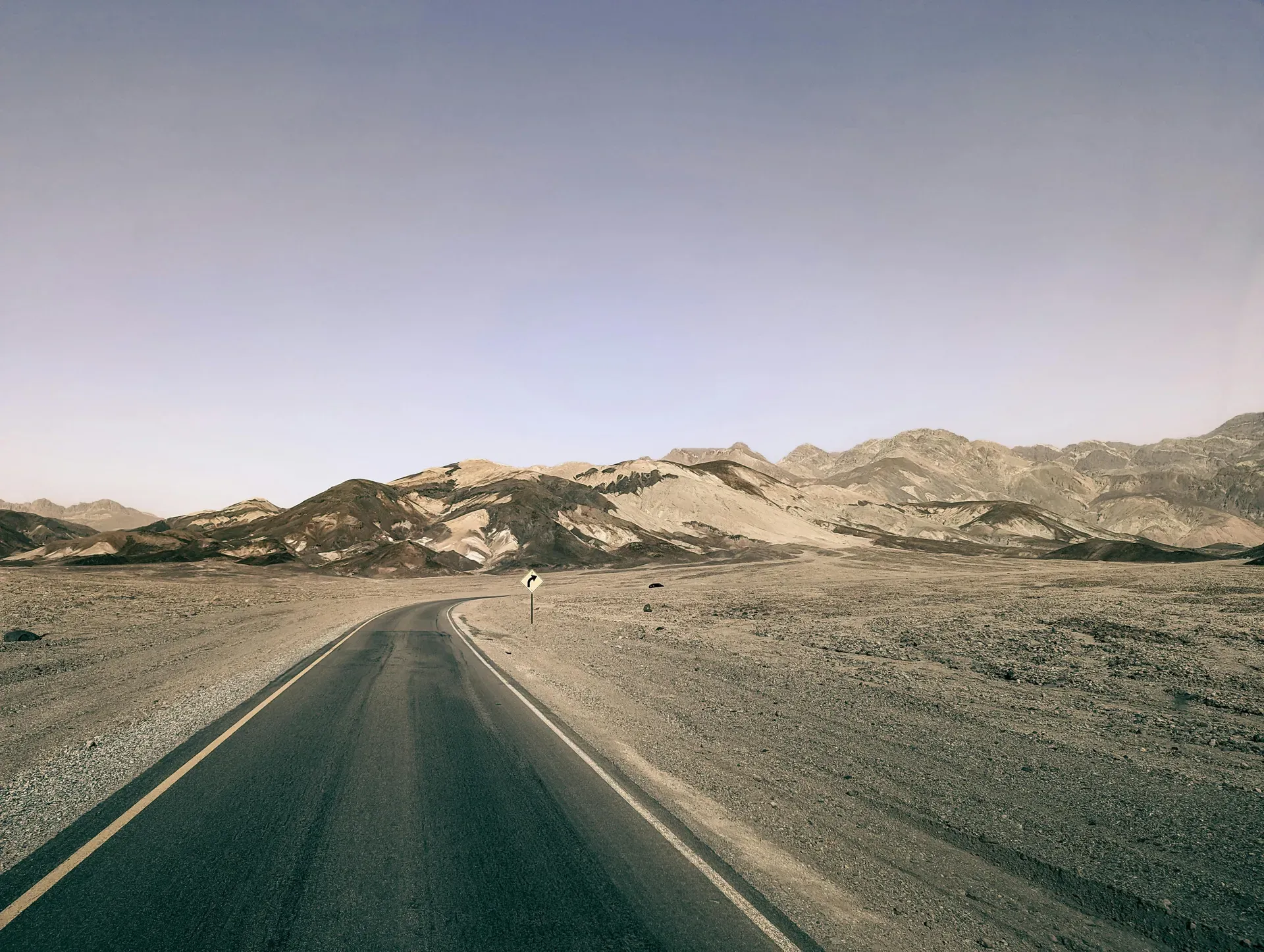
Death Valley spans 3.3 million acres across Eastern California as the hottest, driest, and lowest national park in the United States. Extreme elevation changes drop from 11,049-foot mountain peaks down to salt flats sitting 282 feet below sea level.
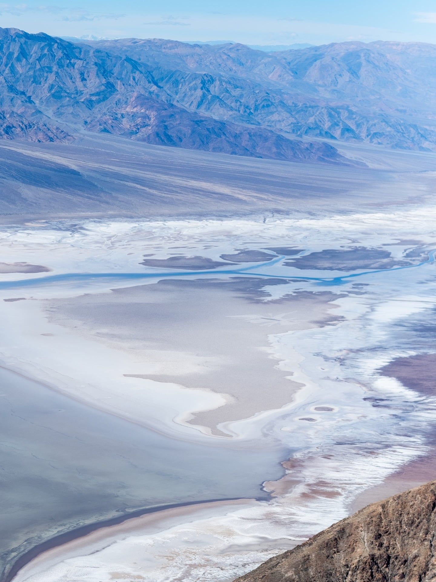
Death Valley occupies 3.3 million acres of the northern Mojave Desert in Eastern California, bordering the Great Basin Desert. Vertical block faulting created a 3,000-square-mile graben that drops to 282 feet below sea level at Badwater Basin. Visitors walk across vast geometric salt crusts that crunch underfoot. Just 20 miles west, Telescope Peak rises to 11,049 feet, creating an extreme topographic contrast. The sheer scale of the landscape requires hours of driving between major points of interest. A trip from the eastern entrance at Death Valley Junction to the western boundary near Panamint Springs covers over 70 miles of winding, desolate highway. During rare wet years, a temporary shallow lake forms on the valley floor, casting mirror reflections of the surrounding Amargosa and Panamint mountain ranges.
Summer temperatures regularly exceed 120°F and occasionally reach 130°F. The intense heat makes outdoor activity dangerous from April through October. Winter brings 60°F to 80°F daytime highs, drawing hikers to the sand dunes near Stovepipe Wells and the 2,000-year-old Ubehebe Crater. Flash floods remain a constant threat year-round. Rain falling miles away can send torrents of water and debris crashing through narrow slot canyons without warning. Single-vehicle rollover accidents on the long desert roads are the leading cause of visitor fatalities. Drivers must obey posted speed limits, wear seatbelts, and shift to low gear on steep downhill grades.
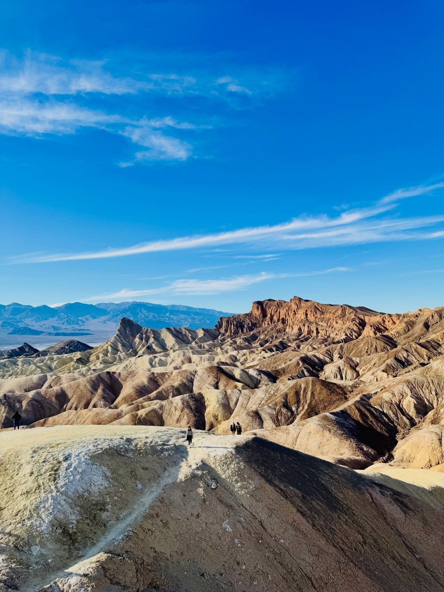
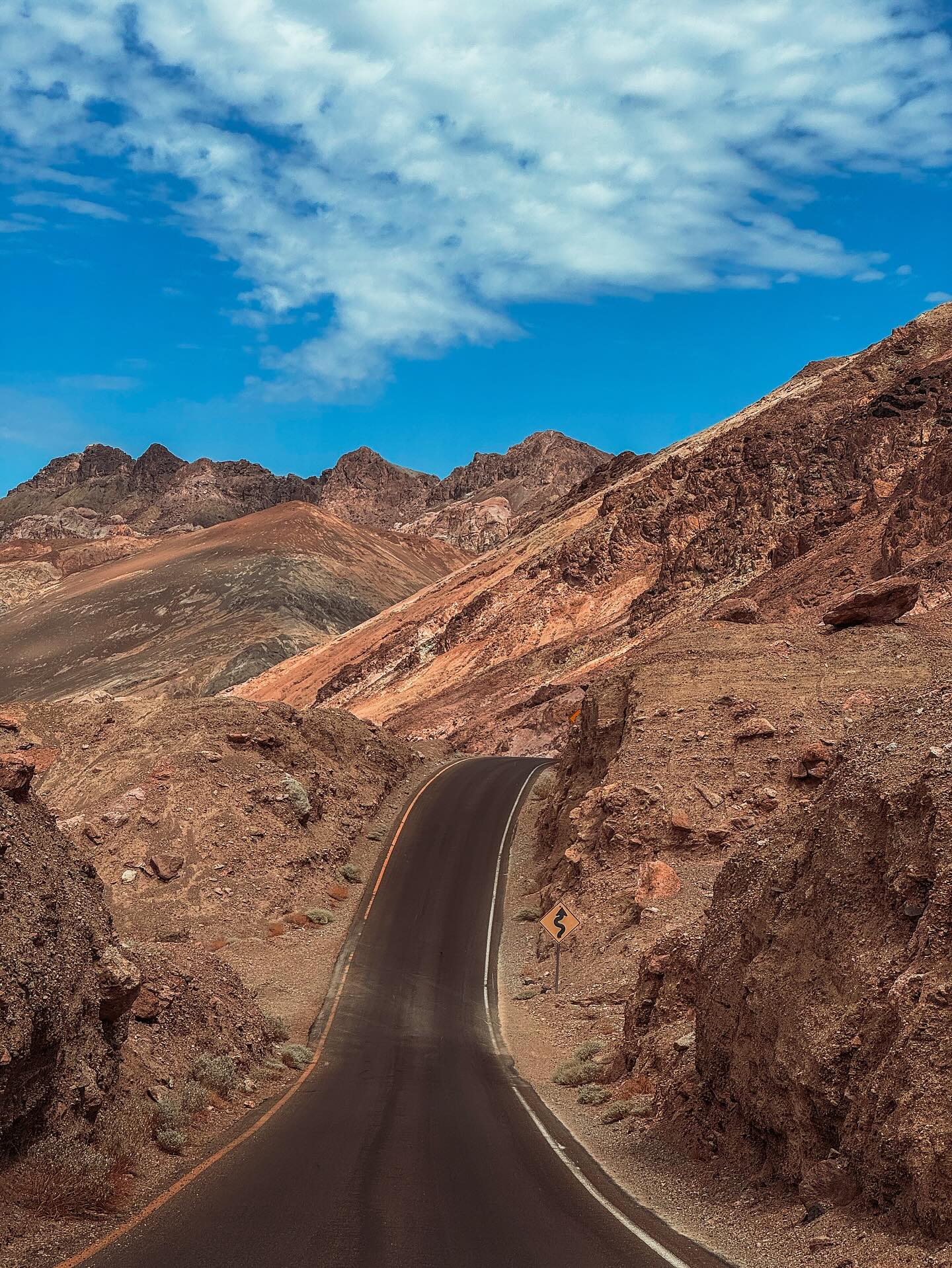
The landscape lacks vegetation, exposing millions of years of geological history. Volcanic mineral deposits oxidize on the hillsides of Artist's Drive, painting the rock faces in shades of green, pink, gold, and purple. Salt Creek sustains rare pupfish in highly saline water surrounded by marsh grass. At Dante's View, a paved overlook sits 5,475 feet above the valley floor, allowing visitors to see the lowest and highest points in the park simultaneously. Zabriskie Point offers panoramic views of a golden, undulating sea of layered badlands and ridges. Photographers gather here before dawn to watch the first morning light hit the rock formations. A short, paved 1/4-mile path leads up a graded hill to the main viewing area.
A standard four-day itinerary allows enough time to hike the canyons, drive the scenic loops, and watch the sunrise hit the badlands. You must pay a $30 vehicle entrance fee at automated kiosks or the visitor center. Display the receipt on your dashboard immediately. Park rangers patrol the remote lots daily and issue citations for missing passes.
The Timbisha Shoshone tribe has inhabited the valley for over a millennium. They engineered seasonal migration routes, moving from the valley floor in winter to the surrounding Panamint and Amargosa mountain ranges during the extreme summer heat. They harvested mesquite beans on the valley floor and gathered piñon nuts in the higher elevations. The region received its current English name in 1849. A party of gold-seeking emigrants, attempting a shortcut to the California gold fields, became trapped in the basin for weeks. They slaughtered their oxen for food and burned their wagons for fuel before finally finding a route out over the Panamint Mountains. One departing member reportedly looked back and said, "Goodbye, Death Valley," cementing the ominous title.
Mining operations transformed the desert economy in the 1880s. Prospectors discovered lucrative borax deposits on the valley floor, a mineral used in soaps and industrial compounds. The Harmony Borax Works operated from 1883 to 1888, processing the mineral under brutal conditions where summer heat prevented the borax from crystallizing properly. Teams of 18 mules and two draft horses hauled massive wagons loaded with 36,500 pounds of borax across 165 miles of waterless desert to the nearest railroad in Mojave. The journey took ten days in each direction. You can still view the preserved ruins of the processing plant and one of the original wagons along a short paved path near Furnace Creek.
President Herbert Hoover designated the region a national monument in 1933. The Civilian Conservation Corps arrived shortly after, building roads, trails, and the first permanent tourist facilities. They constructed the stone buildings at the Wildrose Charcoal Kilns and graded the road to Dante's View. Early surveyors mapped the extreme elevation changes in the late 19th century. They established the route to Telescope Peak, a strenuous 14-mile round-trip trail that climbs from 8,000 feet to the park's highest summit at over 11,000 feet. Hikers passing through groves of ancient bristlecone pine trees gain 360-degree views of the entire valley. Congress elevated the area to a national park in 1994, expanding its protected boundaries to 3.3 million acres. This legislation officially recognized it as the largest national park in the contiguous United States.
Today, abandoned mine sites dot the backcountry. These unstable tunnels contain hidden vertical drops and pockets of lethal gas. Stay on marked trails when exploring historic sites like the Rhyolite Ghost Town, located 40 minutes from Furnace Creek. Rhyolite features crumbling concrete ruins and an old train station from the early 1900s gold rush. Never enter any old mine shafts or tunnels, as the decaying timber supports collapse without warning.
Vertical block faulting shaped Death Valley approximately 30 million years ago. The valley floor sank while the Amargosa Range to the east and the Panamint Range to the west pushed upward. This tectonic activity created a 3,000-square-mile rift valley. Badwater Basin sits at the bottom of this depression, 282 feet below sea level. The basin floor consists of a massive salt pan covering 200 square miles. Evaporating water leaves behind sodium chloride, creating sharp, jagged salt crystals. Walkers need sturdy water shoes or sandals with thick soles, as the crust easily slices through bare skin and thin fabric. Near Badwater Basin, the Devil's Golf Course features a massive expanse of rock salt eroded by wind and rain into jagged spires. The terrain is exceptionally rough. Visitors can hear a faint popping sound as billions of tiny salt crystals burst apart in the heat.
Volcanic activity left deep scars across the northern section of the park. Ubehebe Crater spans half a mile wide and plunges hundreds of feet deep. A massive steam explosion blasted this hole through the bedrock just 2,000 years ago. Hikers walking the steep rim trail encounter loose volcanic cinders and constant high winds. You can hike down to the bottom of the crater, but the climb back up the loose gravel takes three times as long. Further south, the Trona Pinnacles rise from the dry bed of Searles Lake. More than 500 calcium carbonate tufa spires tower over the desert floor, forming a jagged, alien landscape.
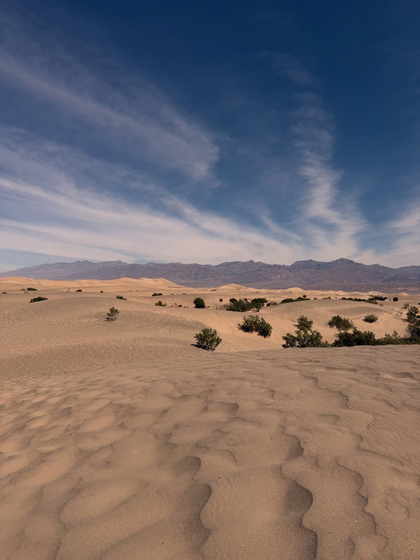
Wind shapes the Mesquite Flat Sand Dunes near Stovepipe Wells. Quartz and feldspar grains blow down from the Cottonwood Mountains and become trapped in the basin. The dunes rise up to 100 feet tall. Shifting sands erase footprints within hours. Carry a GPS device if you hike past the first ridge, as the uniform terrain causes rapid disorientation. The dunes absorb extreme heat during the day, making them safe to explore only in the early morning or late afternoon.
Water exists in isolated, surprising pockets. Darwin Falls sits at the end of a two-mile round-trip hike through a narrow, rocky canyon. A year-round freshwater stream feeds a 20-foot waterfall surrounded by lush green vegetation. This oasis provides a stark contrast to the surrounding dry and dusty desert landscapes. At Ash Meadows National Wildlife Refuge, crystal-clear spring pools sustain rare, endemic plants. Wheelchair-accessible boardwalks allow visitors to view these unique desert wetlands. Venomous scorpions and rattlesnakes hide under rocks near these water sources. Look carefully before placing your hands or feet down while scrambling.
The Timbisha Shoshone consider the valley their ancestral homeland, referring to it as "Tümpisa," meaning rock paint. This name originates from the red ochre clay found in the valley, which the tribe traditionally used for face paint and healing. In 2000, the federal government returned 7,700 acres of land within and around the park to the Timbisha Shoshone, establishing a permanent reservation at Furnace Creek. Tribal members continue to harvest mesquite beans and pine nuts using traditional methods passed down through generations. They actively participate in park management decisions, ensuring the protection of sacred sites and historical migration routes.
Hollywood filmmakers frequently use the desolate landscape to represent alien planets and post-apocalyptic wastelands. The stark sand dunes and bizarre tufa spires of the surrounding Mojave Desert provided the backdrop for numerous science fiction films. Location scouts favor the Mesquite Flat Sand Dunes and Artist's Palette for their otherworldly appearance and lack of modern infrastructure. Commercial filming requires a Special Use Permit obtained 30 to 60 days in advance, and crews must follow strict guidelines to prevent damage to the fragile badlands.
The harsh environment attracts scientists studying extremophiles. Researchers monitor the Salt Creek pupfish to understand how life adapts to highly saline water and extreme temperature fluctuations. Geologists use the exposed fault lines and alluvial fans as a natural laboratory to study tectonic movement and desert physiography. The extreme conditions mimic environments found on other planets, drawing astrobiologists testing equipment for future space missions. Do not touch the water in Salt Creek, as oils from human skin can disrupt this fragile, isolated ecosystem.
The valley holds the record for the highest reliably recorded air temperature on Earth at 134°F (56.7°C) in 1913.
Salt Creek sustains the pupfish, a rare species that survived from an ancient lake that dried up 10,000 years ago.
Boulders on the Racetrack Playa move across the dry lakebed, pushed by thin sheets of ice and wind during winter.
The stark, otherworldly terrain of the park has been used as a filming location for several major science fiction movies.
The park transitioned to a completely cashless fee system in 2023, requiring credit cards or digital payments at all automated machines.
Speed limits are heavily enforced by the National Park Service and California Highway Patrol to prevent single-vehicle rollover accidents.
Operating unmanned aircraft like quadcopters is strictly illegal within park boundaries to protect wildlife and preserve the silence.
The standard entrance fee is $30 per private vehicle, valid for seven days. Motorcycles cost $25, and individual walk-ins or bicyclists pay $15. The park operates a cashless system, so you must pay with a credit or debit card.
Badwater Basin sits at 282 feet (86 meters) below sea level. This massive salt flat is the lowest land elevation point in North America.
November through March offers the safest conditions. Daytime temperatures range from 60°F to 80°F, allowing for hiking and exploring. Summer visits are highly dangerous due to temperatures exceeding 120°F.
No. Launching, landing, or operating unmanned aircraft is strictly prohibited within park boundaries. Violators face heavy fines from the National Park Service.
Telescope Peak reaches an elevation of 11,049 feet (3,368 meters). It stands in the Panamint Range, less than 20 miles west of the lowest point at Badwater Basin.
No public transportation or shuttle service operates within Death Valley. You must bring a private vehicle or join a permitted commercial tour group to get around.
Pets are allowed but restricted to paved roads, developed pullouts, and campgrounds. They must remain on a leash at all times and are prohibited on most hiking trails.
Gas prices at Furnace Creek and Stovepipe Wells typically range between $5 and $6 per gallon. Fill your tank in surrounding towns like Pahrump or Beatty before entering the park boundaries.
The Salt Creek Trail features a one-mile wheelchair-accessible wooden boardwalk loop. Major viewpoints like Badwater Basin and Dante's View also offer paved paths and ramps.
Wear sturdy water shoes or sandals with thick soles. The white salt crust at Badwater Basin consists of sharp crystals that can easily cut bare feet or puncture thin footwear.
Browse verified tours with free cancellation and instant confirmation.
Find Tours